|
Orcas Island
is sometimes called "The Magic Isle" because of the quality
of its beauty and vibration - and what happens when you live here.
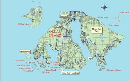
We
are the largest island in the San Juan Island archipelago in Washington
State and located in the heart of the Salish Inland Sea between Canada
and the USA in the Pacific Northwest.
Here are some brief details of its Geography from Wikipedia:
With a land area of 57.3 square miles (148.4 km²) and a population
of 4,453 (2000
census), Orcas Island is slightly larger, but less populous, than
neighboring San
Juan Island. Orcas is shaped like a pair of saddlebags, separated
by fjord-like
East Sound, with Massacre
Bay on the south side, and tiny Skull
Island just off the coast. At the northern end of East Sound is the
village of Eastsound,
the largest town on Orcas and the second largest in San Juan County.
In 1989 the Lummi Nation
regained a village and burial site on Orcas Island's Madrona Point near
Eastsound, and now operates it as Madrona Point Park, a public-access
preserve characterized by hundreds of twisting madrona
trees sprouting from the rocky shoreline, with an easy hiking trail
around the point.
Other, smaller towns - or hamlets - on the island include Orcas (where
the inter-island/mainland
ferry lands), West Sound (technically part of Eastsound), Deer
Harbor, Rosario (technically part of Eastsound), Olga and Doe
Bay.
Find out more
about the island.
|
|
-jr6.jpg)